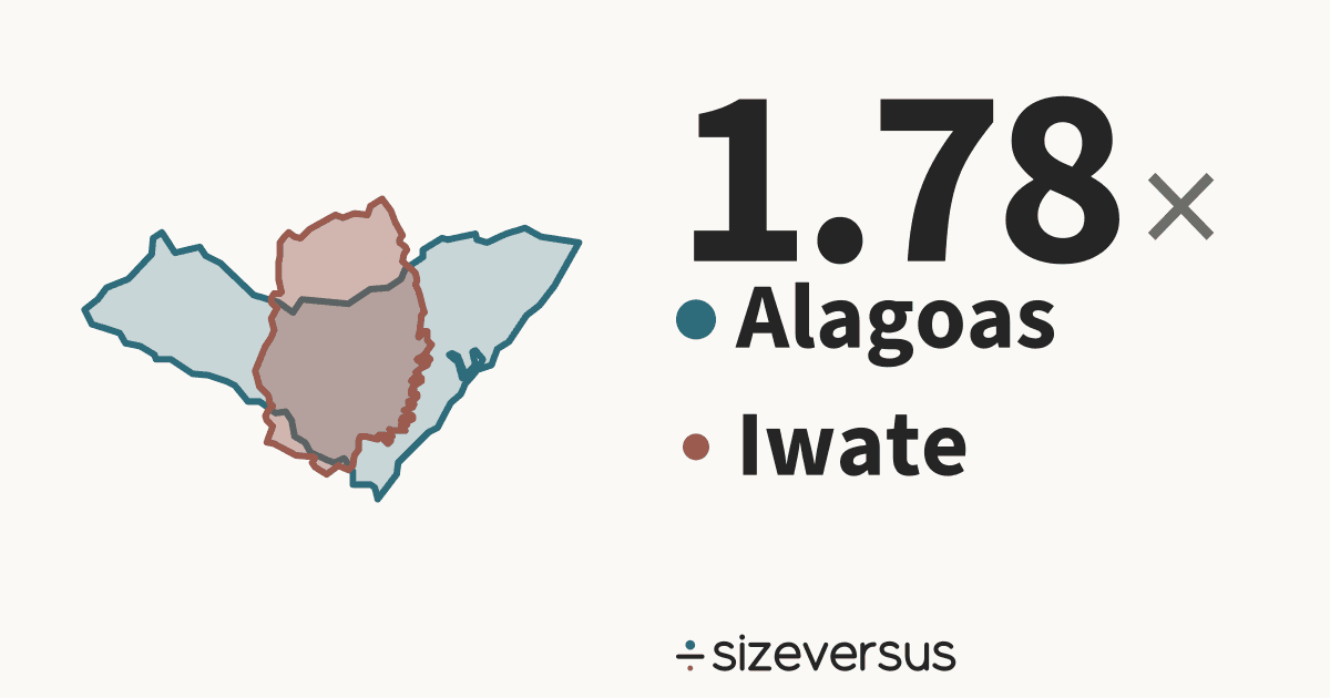
Alagoas is 1.78× the size of Iwate
Alagoas (state of Brazil) covers about 27,600 km² (10,700 mi²) and Iwate (prefecture of Japan) about 15,500 km² (5,970 mi²). Below, both outlines are drawn at one scale and centred on each other.
- 27,600km²Alagoas
- 15,500km²Iwate
100 km
- Alagoas
- Iwate
What fits
- Iwate is 56% of the size of Alagoas.
- Alagoas is larger by 12,100 km² (4,690 mi²), which is 78% of the area of Iwate.
- Measured in Belgiums: Alagoas is about 0.90, Iwate about 0.50.
How they differ
- Alagoas also has the larger population: 3.1 million against 1.2 million, 2.59× as many people.
- Per square kilometre that is 113 in Alagoas against 78 in Iwate: Alagoas is 1.45× as densely populated.
- Their centres are about 16,700 km apart.
- A standard web map misstates the comparison: Alagoas at 10°S is drawn about 1.0× too large and Iwate at 40°N about 1.7×, so the map shows Alagoas as 1.09× the size of Iwate instead of 1.78×.
- Together Alagoas and Iwate cover 43,100 km², close to the size of Denmark (42,700 km², 0.9% smaller).
- The gap between them, 12,100 km², is about the size of Vanuatu (12,300 km²).
- At Iwate's density, Alagoas would have 2.2 million people (it has 3.1 million). At Alagoas's density, Iwate would have 1.8 million (it has 1.2 million).
- Iwate's centre is 49.1° of latitude, about 5,460 km, farther north than Alagoas's.
- Alagoas is the 25th largest of the 27 states and districts of Brazil and covers 0.3% of its area; it is the 4th most densely populated of them.
- Iwate is the 2nd largest of the 47 prefectures of Japan and covers 4.1% of its area; it is the 46th most densely populated of them.
- Iwate lies about 49° of latitude (roughly 5,460 km) north of Alagoas, on the other side of the equator.
- Shared out evenly, each person in Alagoas would have about 8,830 m² and each person in Iwate about 12,830 m².
- Laid side by side, Alagoas and Iwate would cover 43,100 km², about the same size as Denmark.
- Together they have 4.3 million people, about as many people as Kuwait.
Side by side
| Alagoas | Iwate | |
|---|---|---|
| Is a | StateBrazil | PrefectureJapan |
| Area, measured | 27,600 km²10,700 mi² | 15,500 km²5,970 mi² |
| Official area | 27,800 km²Wikidata | 15,300 km²Wikidata |
| Rank by area | 25th of 27in Brazil | 2nd of 47in Japan |
| Population | 3.1 millionWikidata, 2022 | 1.2 millionWikidata, 2021 |
| Rank by population | 19th of 27in Brazil | 32nd of 47in Japan |
| Density | 113 per km² | 78 per km² |
| Capital | Maceió | Morioka |
| Latitude range | 11°S to 9°S | 39°N to 40°N |
Population: Wikidata 2022 and Wikidata 2021. Official figures: Wikidata (CC0).
- Wikidata's official figure of 27,800 km² agrees with our measured area of 27,600 km², to within 2%.
- Wikidata's official figure of 15,300 km² agrees with our measured area of 15,500 km², to within 2%.
Similar in size to Alagoas
Similar in size to Iwate
More from the same country
More comparisons
Send it to someone who won’t believe it

Sources and method
- Outlines
- Natural Earth, 1:10m Admin 1 - States, Provinces, public domain
- Boundary
- De facto, as drawn by Natural Earth. A region is drawn whole, every island included; a country is its main territory.
- Area
- Measured on the WGS84 ellipsoid from the full-detail outlines, shown rounded.
- Drawing
- Each outline is projected with an equal-area projection centred on its own centroid, so areas stay true and the two can be laid over each other.
- Data built
- 2026-11-12