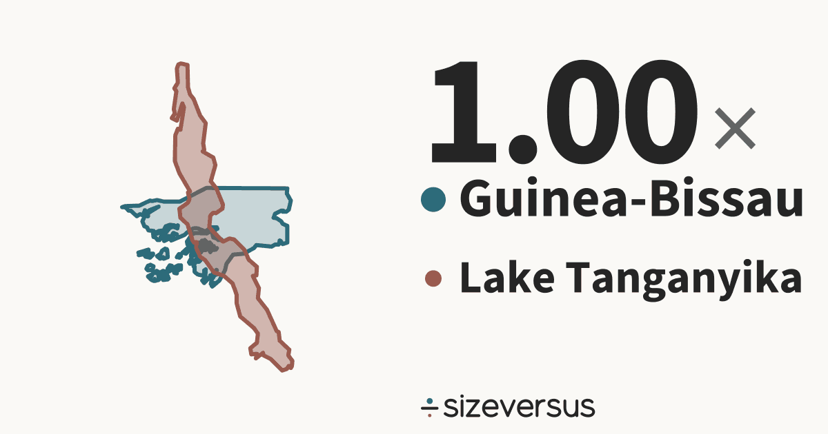
Guinea-Bissau and Lake Tanganyika are almost exactly the same size
Guinea-Bissau (country) covers about 32,800 km² (12,700 mi²) and Lake Tanganyika (lake) about 32,800 km² (12,600 mi²). Their outlines are laid over each other below at one scale. The Lake Tanganyika outline is Natural Earth’s, checked against the published area.
- 32,800km²Guinea-Bissau
- 32,800km²Lake Tanganyika
100 km
- Guinea-Bissau
- Lake Tanganyika
What fits
- Lake Tanganyika is 100% of the size of Guinea-Bissau.
- The measured areas differ by 74.1 km², less than half a percent: closer than the measurement itself is certain.
- Measured in Belgiums: Guinea-Bissau is about 1.07, Lake Tanganyika about 1.07.
How they differ
- Their centres are about 5,360 km apart.
- Together Guinea-Bissau and Lake Tanganyika cover 65,600 km², close to the size of Lithuania (64,900 km², 1.0% smaller).
- Guinea-Bissau's centre is 18.2° of latitude, about 2,030 km, farther north than Lake Tanganyika's.
- Guinea-Bissau ranks 139th of 212 countries by area.
- Lake Tanganyika is a lake and ranks 6th of the 104 lakes on sizeversus by area.
- Laid out flat, Guinea-Bissau stretches about 195 km north to south and 333 km east to west; Lake Tanganyika about 608 km by 238 km.
- Poured over Guinea-Bissau, the 18,900 km³ that Wikidata records for Lake Tanganyika would stand 576 m deep.
- Wikidata’s published figure of 32,900 km² agrees with our measured 32,800 km², to within 2%.
Who wins on what
| Measure | Winner | By |
|---|---|---|
| Larger area | Guinea-Bissau | 1.00× |
| Farther north | Guinea-Bissau | 18.2° of latitude |
Both against the same yardsticks
| Yardstick | Guinea-Bissau | Lake Tanganyika |
|---|---|---|
| Belgium 30,700 km² | 1.07× | 1.07× |
| United Kingdom 244,000 km² | 0.13× | 0.13× |
| Germany 358,000 km² | 0.09× | 0.09× |
| Japan 374,000 km² | 0.09× | 0.09× |
| France 548,000 km² | 0.06× | 0.06× |
| India 3,151,000 km² | 0.01× | 0.01× |
| Brazil 8,473,000 km² | 1 in 258 | 1 in 259 |
| United States 9,447,000 km² | 1 in 288 | 1 in 288 |
| Russia 16,980,000 km² | 1 in 517 | 1 in 518 |
Each figure is the place's area divided by the yardstick's.
Side by side
| Guinea-Bissau | Lake Tanganyika | |
|---|---|---|
| Is a | CountryAfrica | Lakelake on sizeversus |
| Area, measured | 32,800 km²12,700 mi² | 32,800 km²12,600 mi² |
| Area, published | 36,100 km²Wikidata | 32,900 km²Wikidata |
| Rank by area | 139th of 212countries | 6th of 104lakes |
| Greatest depth | – | 1,433 mWikidata |
| Volume | – | 18,900 km³ |
| Latitude range | 11°N to 13°N | 9°S to 3°S |
| On the shore | – | 4 on the shore |
Published figures: Wikidata (CC0). A lake or a sea has no legal boundary: the measured area is that of Natural Earth’s outline, and it is shown beside the published one.
- Natural Earth’s outlines of Tanzania, the Democratic Republic of the Congo, Zambia and Burundi contain or lie within 4 km of the outline of Lake Tanganyika. That is what its geometry says, and it is not a statement about who owns the water or where any border runs in it.
Similar in size to Guinea-Bissau
Similar in size to Lake Tanganyika
More comparisons
Send it to someone who won’t believe it

Sources and method
- Outlines
- Lakes and seas: Natural Earth 1:10m physical vectors (public domain), kept only where the measured area is within 10% of the published one. Countries and regions: Natural Earth, 1:10m Admin 0 and Admin 1, public domain.
- Boundary
- De facto, as drawn by Natural Earth. A lake or a sea has no legal boundary of its own; the outline is a cartographic one.
- Area
- Measured on the WGS84 ellipsoid from the full-detail outlines, shown rounded. The published figure comes from Wikidata (CC0), fetched 2026-11-11, and is shown beside the measured one.
- Drawing
- Each outline is projected with an equal-area projection centred on its own centroid, so areas stay true and the two can be laid over each other.
- Data built
- 2026-11-11