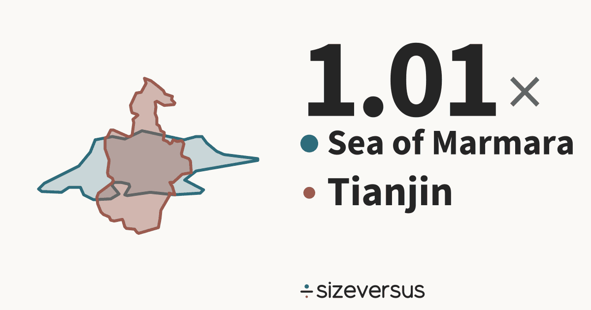
Sea of Marmara is 1.01× the size of Tianjin
The Sea of Marmara (sea) covers about 11,600 km² (4,460 mi²) and Tianjin (municipality) about 11,500 km² (4,430 mi²). Below, both outlines are drawn at one scale and centred on each other. The Sea of Marmara outline is Natural Earth’s, checked against the published area.
- 11,600km²Sea of Marmara
- 11,500km²Tianjin
50 km
- Sea of Marmara
- Tianjin
What fits
- Tianjin is 99% of the size of Sea of Marmara.
- Sea of Marmara is larger by 83.9 km² (32.4 mi²), which is 0.7% of the area of Tianjin.
- Measured in Belgiums: Sea of Marmara is about 0.38, Tianjin about 0.37.
How they differ
- Their centres are about 7,230 km apart.
- Together Sea of Marmara and Tianjin cover 23,000 km², close to the size of Belize (22,300 km², 3.2% smaller).
- Sea of Marmara's centre is 1.4° of latitude, about 160 km, farther north than Tianjin's.
- The Sea of Marmara is a sea and ranks 41st of the 42 seas on sizeversus by area.
- Tianjin is a municipality of China; it is not drawn with its waters removed, and its measured area is the Natural Earth outline's.
- Laid out flat, the Sea of Marmara stretches about 84 km north to south and 268 km east to west; Tianjin about 189 km by 115 km.
- Poured over Tianjin, the 3,378 km³ that Wikidata records for the Sea of Marmara would stand 294 m deep.
- Wikidata’s published figure of 11,400 km² agrees with our measured 11,600 km², to within 2%.
Who wins on what
| Measure | Winner | By |
|---|---|---|
| Larger area | Sea of Marmara | 1.01× |
| Farther north | Sea of Marmara | 1.4° of latitude |
Both against the same yardsticks
| Yardstick | Sea of Marmara | Tianjin |
|---|---|---|
| Belgium 30,700 km² | 0.38× | 0.37× |
| United Kingdom 244,000 km² | 0.05× | 0.05× |
| Germany 358,000 km² | 0.03× | 0.03× |
| Japan 374,000 km² | 0.03× | 0.03× |
| France 548,000 km² | 0.02× | 0.02× |
| India 3,151,000 km² | 1 in 273 | 1 in 275 |
| Brazil 8,473,000 km² | 1 in 733 | 1 in 738 |
| United States 9,447,000 km² | 1 in 817 | 1 in 823 |
| Russia 16,980,000 km² | 1 in 1,469 | 1 in 1,480 |
Each figure is the place's area divided by the yardstick's.
Side by side
| Sea of Marmara | Tianjin | |
|---|---|---|
| Is a | Seasea on sizeversus | MunicipalityChina |
| Area, measured | 11,600 km²4,460 mi² | 11,500 km²4,430 mi² |
| Area, published | 11,400 km²Wikidata | 11,900 km²Wikidata |
| Rank by area | 41st of 42seas | – |
| Greatest depth | 1,370 mWikidata | – |
| Volume | 3,378 km³ | – |
| Latitude range | 40°N to 41°N | 39°N to 40°N |
| On the shore | 1 on the shore | – |
Published figures: Wikidata (CC0). A lake or a sea has no legal boundary: the measured area is that of Natural Earth’s outline, and it is shown beside the published one.
- Natural Earth’s outlines of Turkey lie within 25 km of the outline of the Sea of Marmara. That is what its geometry says, and it is not a statement about who owns the water or where any border runs in it.
Similar in size to Sea of Marmara
Similar in size to Tianjin
More comparisons
Send it to someone who won’t believe it

Sources and method
- Outlines
- Lakes and seas: Natural Earth 1:10m physical vectors (public domain), kept only where the measured area is within 10% of the published one. Countries and regions: Natural Earth, 1:10m Admin 0 and Admin 1, public domain.
- Boundary
- De facto, as drawn by Natural Earth. A lake or a sea has no legal boundary of its own; the outline is a cartographic one.
- Area
- Measured on the WGS84 ellipsoid from the full-detail outlines, shown rounded. The published figure comes from Wikidata (CC0), fetched 2026-11-11, and is shown beside the measured one.
- Drawing
- Each outline is projected with an equal-area projection centred on its own centroid, so areas stay true and the two can be laid over each other.
- Data built
- 2026-11-11